Heat Maps Layer

After many bug fixes and performances improvements we finally got around to a requested feature.  Google Maps includes a heat map layer, so there is now an option to enable it.

In addition, the opacity and radius of the heat map can be set.  There is an option to view the heat map alone or the heat map with pins.

Heat Map Options

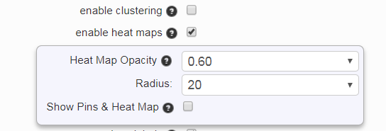
Heat maps provide another way to view the density of pins.  Red areas indicate a high density of pins the color fades to a light green as the density decreases.  A good sample with heat maps enabled is the 14,000 zip code map.  It shows a lot of zip codes on the east coast of the USA.

Export distance from a location

The distance from any point to the other locations can now be exported.   Use the nearby filter and export options (see https://www.easymapmaker.com/support/how-can-i-export-data-to-excel-within-a-radius/).  Also enable the show distance option when filtering by radius.  A column will be added to the exported excel file and will have a header value of something similar to:  “distance from 1415 E ILLINOIS Dallas, TX 75212 in miles”

The circle radius now appears in the generated image or pdf file when downloading the pdf or image of the map.

Finally, the newest version of the google maps api is being used (3.30).  Google updates this a few times per year.  No major changes should be noticed, but a fix was made to allow embedded maps to work better on mobile and tablet devices.  Legacy/free maps created before October, 2017 are deprecated, so changes Google makes to the api will flow through without 100% backward compatibility.  These deprecated free maps will most likely be migrated to the new system on October 2018 (along with the limitations).

As always, get mapping!

The EasyMapMaker Team

High Resolution images and pro and premium (subscription) services

The long awaited high resolution image generator has finally been released along with our subscription services.  Plenty of people have been asking about paying for our service.

Some of the added features include:

  1. High speed geo-coding, up to 50 addresses per second for datasets larger than 250 entries.  We might be able to bump this up to 100.  In reality it is more likely to be around 35-40 entries per second.  Maps that would take 4 hours (9,000 entries) with the old bulk geo-coder can be done in 4-5 minutes.  High speed geo-coding is queue based, so if someone were to attempt 100K items everyone would wait for them.  For now there is a limit of 10K items that can be added to a premium map.  This should prevent any major delays.  Small datasets will also not be “forced” to wait behind any larger jobs.
  2. Automatic image exporting.  This includes radius around a point, pin labels, custom images, and optionally a category legend.  Currently this is limited in size to 10800×7200, but our image generator has produced images as large as 14400×10800.  We hope to add custom poster size images in the future.
  3. A small addition is fixed pin numbers.  When you have between 1 and 99 locations, you can have a numbered column and use that value.
  4. “Improved” marker images.  We made an attempt to improve the pin images.

All maps created before 9/30/2017 will continue to use the old code base and retain whatever features they had.

A brief history of EasyMapMaker is we started out with a mission to bring affordable maps with rich features to those who did not want to pay high prices for few features.  Our goal is to continue to add features as requested by users.  Plenty of features have come from user requests, such as radius around a point, custom images, custom logo, and passwords.  Most of these features have gone into our subscription bucket.


As always, get mapping.

The EasyMapMaker Team


Faster map loading for large data sets

We released another improvement to allow maps to load and perform much better when clustering is enabled for large data sets.  Maps with over 100K locations now work, but still have some lag.  The overall improvement for the initial loading of the pins has been improved by up to a factor of 100.  Please note this is not for map creation, it is after the map has been created for others to view. 

We recommend limiting maps to under 50K locations.  While having over 100K will work and perform reasonable well.  Large data sets (anything over 3K locations) should have clustering enabled otherwise.  Maps with over 20K locations without clustering will render very slowly.

A few other bugs were fixed as well.

The EasyMapMaker Team

P.S. As always get mapping!

Map navigation, clustering and other custom updates

We did a release last week to add some more great features to EasyMapMaker including the following:

  1. Ip Address geo-coding.  Some information will get added such as city, state, and zip code if these can be determined
  2. Ability to hide the logo when using advanced maps
  3. Set the text for your custom logo
  4. Set the url for your custom logo
  5. Automatic image sizing for different devices
  6. Ability to select a color when not using groups
  7. The Mouse-Over value can now be set from a column instead of defaulting to the title
  8. The Pin-Labels can be hidden when zoomed out of the map
  9. The clustering value can be changed from the default pin count to the average/min/max/total of a dollar or numerical value from the data.
  10. When doing a search on the map, a pin can be added to the search location using advanced maps.
  11. A refresh button was added to “reset the map”
  12. The navigation was moved and the functionality was updated so the small circle will follow you as you move.

Thank you for all the great suggestions.  We plan to add some more great features shortly including hiding of the points of interest and the ability to easily zoom in onto a pin.

As always, get mapping!

The EasyMapMaker Team

Improved Security: Map Password Authentication

After numerous requests to make maps more secure other than having a random url, we have added the ability to protect maps with passwords over our secure site: https://www.easymapmaker.com.  The secure site no long has the option for public or private maps.  Maps will default to private.  If you add a password then that is an extra layer of security besides the url.  It also forces the use of our secure site to view or edit the map when there is a password.  Only our English site has map passwords for now.  If you forget your password, you can either change it with the browser (and computer) you used to create the map or through a link sent via email.

As always, get mapping!

The EasyMapMakerTeam

Select map push pin colors

We are working on some great features.  Due to all the requests about changing the marker colors, we added a feature to do just that.  If you have a group selected, you can choose the marker colors you want for it.  There are up to 10 marker colors for regular maps and 20 for advanced.

We also added video tutorials on both map pages.  This should make it easier for you to understand how easy mapping is.

Enjoy!

As always, get mapping!

The EasyMapMaker Team.

Store locator, distance filter, and more fixes

We are pleased to announced more great improvements to easymapmaker.com.  Data can now be filtered based on location and distance with up to 999 km or miles from any location.  This allows for any map to be used a store locator (the search box can also be used to find the nearest location).  This is only available on our advanced maps.  To enable this feature, be sure to check the directions check box.  When the map renders, there is a more options image in the top left corner that will allow a left panel to be displayed.  When results are displayed below the page, the distance can be displayed next to the listings and results are sorted in order by distanced.   Another change was made to our filters.  The dynamic feature can be turned off so the list of available items to filter on remains static.  This was how easymapmaker.com was initially designed, but we wanted to also allow excel like filters.

In addition, we made some fixes to issues with Internet Explorer.   There are likely other issues, but we tried to get the low hanging fruit.  Other bug fixes include adding more locations to the edit page.

We have plenty of more great features in the pipeline and plan to offer some tutorials and more information on how to use our service, as well as to make it even easier.  We know this will be a challenge.

The EasyMapMaker Team.

P.S. Get Mapping!

Easier map editing, dynamic filters

As we try to continue to improve our service, we try to fix bugs and add new features in a timely manner.  Unfortunately it was a few months since we got to some great updates and fixes.

Some of the bug fixes include map editing.  Now all the data from the modified spreadsheet can be pasted and the original geo-coded address will automatically map to addresses that have not changed.  This is a great feature to geo-code 250 items at a time and add up to 2,500 item to the map per day.  There were also issues with removing pins from the map and always generating the KML.  Now KML is optional.  In addition there is an option to allow the mouse wheel to resize the map.

The filters, which can be set on the advanced maps, have been modified to be dynamic and the available filters should change based on the available data as other filters are selected.  This will allow filters to behave similar to filters in excel (all on your own custom google map).

Finally, some information pages have been built to help explain some of the features included in our service.  We have some great things planned including easier map management, tutorials, a FAQ, and more great support to map your data easier.

The EasyMapMaker team

Embedded Maps, KML generator (for google earth)

Unfortunately, there were some bug and features we didn’t get to.  Our latest release includes an updated email with KML for Google Earth and embedded map support to host maps on your site.  The map alias feature has improved as well.  After saving the map, an alias can be set for it.  Previously this could only be done in the edit page.  The original url will work, along with the alias.  There was also an issue of not clearing out aliases when maps were removed.  This should be fixed as well.

To embed a map to a webpage, simply put it in an iframe with the your as your map url, set the height and width to some desired values and your map should be sized correctly.

The KML for google earth should get automatically generated from your data.  This allows EasyMapMaker to be a great tool to convert data into KML and you can see the data differently as well.

The EasyMapMaker Team