Street View Panorama

View the street view panorama near a location on a map.  Street view panorama is provided by Google to allow someone to get a visual display of a street and move through the street.  This is not available for every location, but an attempt will be made to see if it is available when the “Street View Panorama” button is clicked.  When the street view panorama is available it will be placed over the entire map.  There is a button to exit the street view panorama in the upper right.

This option is available to subscribers and can be enabled below the sample marker description (as seen in the image).
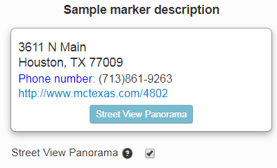
enable street view panorama

Street view panorama is a great way to get a visualization of a street or an area without being there.  It can be used when looking for apartments or houses to get a feel for the nearby houses, streets, and overall neighborhood.   It can also be used to get an overview of an area before traveling or instead of traveling.

A good live example of the street view panorama can be seen at https://developers.google.com/maps/documentation/javascript/examples/streetview-embed


High Resolution images and pro and premium (subscription) services

The long awaited high resolution image generator has finally been released along with our subscription services.  Plenty of people have been asking about paying for our service.

Some of the added features include:

  1. High speed geo-coding, up to 50 addresses per second for datasets larger than 250 entries.  We might be able to bump this up to 100.  In reality it is more likely to be around 35-40 entries per second.  Maps that would take 4 hours (9,000 entries) with the old bulk geo-coder can be done in 4-5 minutes.  High speed geo-coding is queue based, so if someone were to attempt 100K items everyone would wait for them.  For now there is a limit of 10K items that can be added to a premium map.  This should prevent any major delays.  Small datasets will also not be “forced” to wait behind any larger jobs.
  2. Automatic image exporting.  This includes radius around a point, pin labels, custom images, and optionally a category legend.  Currently this is limited in size to 10800×7200, but our image generator has produced images as large as 14400×10800.  We hope to add custom poster size images in the future.
  3. A small addition is fixed pin numbers.  When you have between 1 and 99 locations, you can have a numbered column and use that value.
  4. “Improved” marker images.  We made an attempt to improve the pin images.

All maps created before 9/30/2017 will continue to use the old code base and retain whatever features they had.

A brief history of EasyMapMaker is we started out with a mission to bring affordable maps with rich features to those who did not want to pay high prices for few features.  Our goal is to continue to add features as requested by users.  Plenty of features have come from user requests, such as radius around a point, custom images, custom logo, and passwords.  Most of these features have gone into our subscription bucket.


As always, get mapping.

The EasyMapMaker Team