Map Styles to further customize maps

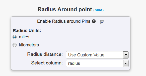
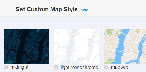
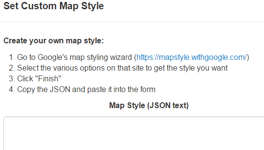
In advanced maps, we added 15 predefined maps styles (including the default).  In addition, you can create your own style using Google’s styling wizard (https://mapstyle.withgoogle.com/ ) or you can use a style found somewhere else.

blog_style_img1

To create your own style select the custom style and paste the JSON data obtained from Google’s styling wizard or another site of your choice.

blog_style_img2

The EasyMapMaker Team


Hide Points of Interest & Easier Zooming

We added a couple more features, fixed some bugs and improved other items.  The new features are:

  1. Hide Points of Interest – this will hide things like restaurant icons and other icons that are visible and possibly undesirable when zooming in
  2. Easily zoom in to a marker with the new zoom icon.  This should be present when an address is displayed.
  3. The paging buttons have been moved down towards the bottom of the page for maps viewed on a PC.

Enjoy the changes.

The EasyMapMaker Team

P.S.  As Always, Get Mapping!

Map navigation, clustering and other custom updates

We did a release last week to add some more great features to EasyMapMaker including the following:

  1. Ip Address geo-coding.  Some information will get added such as city, state, and zip code if these can be determined
  2. Ability to hide the logo when using advanced maps
  3. Set the text for your custom logo
  4. Set the url for your custom logo
  5. Automatic image sizing for different devices
  6. Ability to select a color when not using groups
  7. The Mouse-Over value can now be set from a column instead of defaulting to the title
  8. The Pin-Labels can be hidden when zoomed out of the map
  9. The clustering value can be changed from the default pin count to the average/min/max/total of a dollar or numerical value from the data.
  10. When doing a search on the map, a pin can be added to the search location using advanced maps.
  11. A refresh button was added to “reset the map”
  12. The navigation was moved and the functionality was updated so the small circle will follow you as you move.

Thank you for all the great suggestions.  We plan to add some more great features shortly including hiding of the points of interest and the ability to easily zoom in onto a pin.

As always, get mapping!

The EasyMapMaker Team

Radius (circle) around each pin

Another great feature was added to EasyMapMaker due to quite a few requests.  We added the option on advanced maps to add a circle around all your markers.  You can either use one of our predefined values or set your own in based on your data.  This feature can be combined with pin labels to label the marker (and circle).  During editing the circle will move if you move the marker.

Adding Radius around a point

For a sample look at : Map with circles around the pins.

The EasyMapMaker Team

P.S. As Always Get Mapping!

Even easier to make a custom google map

More improvements were made to EasyMapMaker.com.  You can now drag and drop your excel file into the form or use the traditional copy/paste method.   Another great change is the ability to edit and resave the map from both the map create and map edit page.  The map is now wider as well.  This should make EasyMapMaker the best place for creating custom google maps from your address data!

The latitude and longitude coordinates are now longer displayed in the table.   We wanted to make sure we were in compliance with google’s terms.

As always, get mapping!

The EasyMapMaker Team.


Excel data export and Google Maps directions

We added a coupe new features.  One feature is the ability to export the data on your map directly to excel.  This is automatically added if you have data exporting enabled.

Another feature is to use google maps directions.  There is a ‘Google Maps Directions’ option for this.  It should open up either the google maps app or a page in a new browsers.

As always, keep on mapping!

The EasyMapMaker Team

Improved Security: Map Password Authentication

After numerous requests to make maps more secure other than having a random url, we have added the ability to protect maps with passwords over our secure site: https://www.easymapmaker.com.  The secure site no long has the option for public or private maps.  Maps will default to private.  If you add a password then that is an extra layer of security besides the url.  It also forces the use of our secure site to view or edit the map when there is a password.  Only our English site has map passwords for now.  If you forget your password, you can either change it with the browser (and computer) you used to create the map or through a link sent via email.

As always, get mapping!

The EasyMapMakerTeam

Map language setting in advanced map

There is now the ability to force the language in advanced maps.  It will default to google’s default, which probably right in most cases.

There is also error handling for the edit page to make it very clear when column headers have been added or removed and should not have been.  This will break the map.

As always, get mapping!

The EasyMapMaker Team.